POD[]
The POD is that colonial rule worked in part of Africa. What would have a nation been like if the British Empire (and maybe the French Empire as well) had succeeded in their cultural gaols and also held out much longer, like say until 1972...
Overview[]
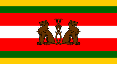
The flag of Muluwheyo.

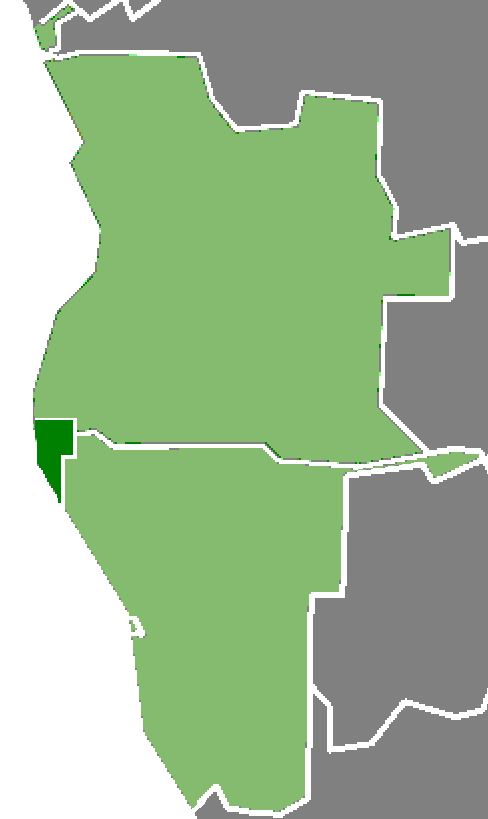
The location of Muluwheyo inbetween namibia and Angola.
Stats[]
- Size- 9,336 sq mi (18,508km2).
- Colony established-1845.
- Population (2010) - 428,325.
- Capital city- Muluwheyo City.
- Former colonial power- The UK.
- Official language- English and Ovambo.
- Other Languages- Herero, Bushman, Darama, Afrikaans, German, Chewa, Ovimbundu, Namaqua and a few Greek and Portuguese speakers.
- Currency- UK £ (official), RSA Rand, Angolan Kwanza and Namibian Rand (unofficaly).
- Ethic groups- 64% Ovambo, 12% White (8% British, 2.5% Afrikaners, 1% Rhodesian Whites, 0.5% Greek), 7% Coloureds, 5% Darama, 4% Herero, 3% Ovimbundu, 1.5% Bushmen, 1% Chewa, 1% Namaqua, 1% Xindonga and 0.5% Tswana.
- Religion- Protestant 64%, 33% Animist and 3% Roman Catholic.
- Top exports- Tin, tin plate, coal, coke, sand, glass and cassava.
- Top imports- Oil, processed food, spare parts, plastics, wire, furniture, building materials, electrical macheiary and Vehicles
- Capital-Muluweyo.
- Biggest city-Muluweyo (115,200 in the city proper and 70,500 in the suburbs).
- Other cities/towns-Point Portugal (65,400), New Tamworth (17,500), Port [Tony] Smith (17,500), John Clifford (15,500), Lupatulaika (17,500), New Dartford (15,550), Boerburg (25,500) and New Warwick (15,450).
- President- Nomzamo Sarah N’ktarvi of the LDP.
- Regime- Semi-presidential republic.
Demographics[]
Thes are the vial statistics of the ATL state of Muluwheyo
Religion[]
64% Protestant, 33% Animist and 3% Roman Catholic.
Literacy[]
98% for whites, 97% for Ovambo/coloureds, 95% Darama, 87% for Chewa and 72% of Bushmen.
Life expectancy[]
72.5 for whites, 72.0 For non-whites other than Bushmen and 67.5 for Bushmen.
The infant mortality rate stands at 10.12 deaths per 1,000 live births for all races (2009).
Honour killings and arranged marriages were outlawed in 2008.
Poverty and jobs[]
Between 1994 and 2006, average annual GDP growth was approximately 8%, however, the desrt interior of the country remains one of the poorest and most underdeveloped in places in Africa.
Housing[]
- The number of urban homes without air-con and/or a private bathroom is 18.5% (2009).
- The number of sub-urban homes without air-con and/or a private bathroom is 38.5% (2009).
- The number of rural homes without air-con and/or a private bathroom is 82.5% (2009).
Agriculture[]
A bad foot and mouth outbreak also hit the republic in 2001, in which 100 (75%of all cattle) were put down and incinerated in the local power station.
")
.jpg "Flickr, USaid.Africa, Maza Wanawake Kwanza Growers Association (1).jpg (1.67 MB)")
Health[]


,_provides_medical_care_to_local_children_during_a_Continuing_Promise_2009_medical_service_.jpg)
Broken Hill heath center in 2009.
The 3 national hospitals (200 beds) are in Muluwheyo City, Port Smith and Boarburg. Lesser hospitals (125 beds) exist at Klenunga, Karonga, Lupatulaika, Port Corfe, Tin City and New Warwick. Local health clinics (5 beds) are also available Mulluo, St.Grace, B'dongo, New Tamworth, Port Daventry, Broken Hill and Koliki.
The nation's leading cause of death in children who survive infancy is malaria. Infants occasionally get rotavirus diarrhea, but mostly survive.
The HIV/AIDS epidemic is a small, but growing problem. The 2011 prevalence rate was estimated to be 2.4% of the adult population.
Stats from 2009 showed that 85% of the population had sustainable access clean drinking water and 93% had sustainable access to reasonable levels of sanitation.
Education[]
Education in is based on the British system and is compulsory for 8 years from 5 or 6 to13 or 14. In 1996, the gross primary enrollment rate was 99.6%, and the net primary enrollment rate was 91.3%. The Muluwheyo City University is the only university, but it is of a high calibre.
")
")
Towns and settlements with over 99 people.[]


A market in Gertudeville.


A beach side building in Port Peach.


A water pump in Mulluo. It was built in 1993, replacing the original from 1973.


Fort Ian, Coastal Region
- Muluwheyo City, Muluwheyo City (115,200),
- Point Portugal town, Point Portugal town (65,400),
- Port Smith, Port Smith (17,500),
- Pilar, Pilar (10,028)
- Maria, Pilar (10,005)
- Borth, Pilar (10,150)
- Dijon, Pilar (5,500)
- Port Esteban, Pilar (12,500)
- Oasis, Far Southern (8,500)
- O'Porto, Pilar (6,500)
- Magdalena, Pilar (7,500)
- Broken Hill, Broken Hill (2,500)
- New Dartford, New Kent (15,550),
- B'dongo, B'dongo (3,300)
- Boerburg, Southern (25,500),
- New Warwick, New Warwick (13,250),
- Outer Muluwheyo suburb-town, Outer Muluwheyo (20,000)
- Pinhead, Outer- Muluwheyo (100)
- Lupatulaika, Lupatulaika (17,500),
- Lupatkarla, New Essen (250),
- Longtown, Far Eastern (2,100),
- Port Corfe, Port Corfe (6,500),
- Koliki, Koliki (1,275),
- Zo-zo, Zo-zo (1,000)
- Zoë, Zo-zo (500)
- Mulawaie, Zo-zo (115)
- Tin City, Tin City (6,500),
- John Clifford, John Clifford (15,500)
- Norriston, Norriston (3,000)
- Coin, Klenunga. (4,200)
- Karonga, Karonga (3,000),
- Tengeru, Tengeru (2,000),
- Port Blair, Far Northern (1,890),
- St. Lawrencia, St. Lawrencia (1,300),
- Cecilia Geiger, Cecilia Geiger (1,200),
- St. Grace, St. Grace (1,400),
- Gertudeville, St. Grace (1,100),
- New Brent, New Brent (2,550),
- Aputa, Eastern (1,500),
- Klenunga, Klenunga (3,576),
- Kelunga, Klenunga (2,337)
- Kaloknieh, Central (1,000),
- Molulu, Molulu (950),
- Kallikal, Central (500),
- Keizerberg, Southern (500),
- Mulluo, Mulluo (450),
- Fort Peter, Central (150),
- Port Brackley, Costal (275),
- Fort Ian, Costal (250),
- Fort Ewan, Molulu (150),
- New Daventry, New Warwick (105),
- Port Arthur, Costal (102),
- Port Eric, Costal (101),
- Port Peach, Southern (100),
- Polly, Western, (1,100),
- Boule, Northern (100),
- Onion, Southern (100)
- New Barnet, Northern (100),
- Tonytown, Northern (100).
- New Durham, New Durham (10,500)
- New Easington, New Durham (9,450)
- Ursula Gomez, Outer Muluwheyo (13,500)
- New Brighton, New Sussex (1,750)
- New Hove, New Sussex (1, 160)
- New Elgin, New Elgin (9,000)
- Haggis, New Elgin (8,500)
- New Ipswich, New Suffolk (5,500)
- New Woodbridge, New Suffolk (3,500)
- Ian Cooper, Ian Cooper (1,700)
- New Tamworth, New Tamworth (17,500)
- Mulilo, New Tamworth (500)
- Pyle (Welsh: Y Pîl ), New Tamworth (4,490)
- Belgrade, Southern (7,000)
- New Essen, New Essen (5,000)
- New Koblenz, New Essen (150)
- Marufu, Marufu (51,200)
- Diogo Cão, Diogo Cão (52,200)
- Port Booth, Southern (1,250)
- New Lisbon, New Lisbon (1,250)
- New Oporto, New Lisbon (250)
- New Kiel, New Lisbon (210)
Local images-[]
See-The Muluwheyo image bank for details.
Maps[]
")
")
")
")
")